How many mountain in Bali do you know? Here is the list :
1. Mt. Agung 3142 m / 9944 feet
Agung is an active volcano, and the highest one in Bali. Don't bother to go up there if you are not fit for hiking! Seriously, there is almost no flat path, 95% of them are slopes.There are 3 routes that I know, I have tried 2 of them.
-From Pura Besakih, the Mother Temple (South West). I haven't try it because I don't want to have problem with the aggressive local guide.
 |
| Mount Agung (volcano), from Besakih Temple |
-From Pura Pasar Agung (South). There are local guide that are quite pushy once you reach the parking area, sometimes I give them money and they let me go without guide.It's the shortest one, doesn't mean it's easy.
After passing the forest, there will be a fork in the middle of the path. If you keep going, you will reach the crater rim only.
 | ||
Sunrise from Mount Agung Crater Rim via Pura Pasar Agung
|
If you take the left route, you will reach the summit, exactly the same one as Besakih route. It will take about 4 hours if you are very fit, but it could be 7 hours if you are not :) Just follow the white marker on the rocks, they are every 5-15 meters.
-From a small temple in Kubu (-8.298769,115.532192, East Side). I have tried it one time, and it was very tough. This is the longest one, the path is not clear, and required climbing skill to reach the summit. I really don't recommend it, unless if you want a real adventure in Bali.
2. Mt. Batukaru 2276 m/ 7467 feet
Even though the elevation is not that high, but the start point is not high either, that means it's a long trek. It has 3 different start point as well. Could be slippery and many leeches in rainy season. Takes about 3 hours, if you are fit. There is a temple on the top, enough for 3 tents to camp.
-From Pura Luhur Batukaru. I have tried one time, using a guide that you can hire at the entrance gate of the temple. It's a pretty long and constant steep (slippery in rainy season). There are some confusing junction, lucky that I had a guide. Once you reach the tunnel under the ferns, you are 200 meters away from the top.
-From Pura Pucak Petali, Jatiluwih. This is my favorite path, start on the right side of the temple. You will see a smaller temple and the jungle start on the left side of it. The trek is pretty steep, inside the lush tropical jungle.
-From Pupuan. I haven't tried, the trail starts from Pura Malen.
3. Mt. Abang (2151 m/ 7057 feet)
There is only one trail that I know, the other trails sounds pretty risky. the start point is in the end of the road here -8.285799,115.409476. About 2-3 hours hike, pretty steep but fun. Not recommended to do in heavy rain, since the trail will be very slippery and close to the cliff.
4. Mt. Catur a.k.a Pucak Mangu (2096 m/ 6876 feet)
There is a beautiful on the top, cool view surrounding when the weather is good. The top is flat, enough to built up to 3 tents, and there are 3 gazebo.
There are two routes that I know.
- From Danau Bratan, Bedugul. I haven't tried and I'm still not sure where exactly is the start point.
- From the end of the Pura Pucak Mangu Street. Most part of the trail are really proper, because many Balinese going up for praying. But in 2017, heavy rain have destroyed some part.
5. Mt. Sangiyang (2087 m/ 6847 feet)
It has two peaks that you can see from Mt. Batukaru, the easy way stated on the side of a temple here -8.295269, 115.100616. The trekking is pretty short, typical forest around Batukaru. Kind of sad that people cut the trees to set tent for praying. And of course they dumb garbage all around, just like Mount Abang.
6. Mt. Pohen (2063 m/ 6768 feet)
I haven't been there, I have read that there is a road to go up, since they built a Geothermal Site.
7. Mt. Tapak (1909 m/ 6263 feet)
Easy trail, pretty steep but fun. Start from Bali Botanical Garden in Bedugul. There is a small temple and cemetery of Muslim Imam. So you might find them staying overnight to pray.
8. Mt. Lesung (1865 m/ 6118 feet)
There are two trail that I know and I have tried both of them. There is a small temple on the top, surrounded by trees. You will need to climb it if you want to see the view. Try to go down to the old crater and find the mysterious Lubang Nagaloka.
-From Pura Dalem Tamblingan. The trail is easy, but you will meet some intersection, i got lost one time.
-From here -8.286191, 115.100523. How do i find it? By google map :) This is easier and pretty short trail, but we need to go around the crater rim to get to the summit.
9. Mt Adeng (1826 m/ 5990 feet)
I haven't been there.
10. Mt Batur (1717 m/ 5633 feet)
It's the most famous one, very touristy, but very beautiful as well. I have been here many times. There are different ways to go up, whether pay or not.
-From the Association, very expensive and you have to use a local guide, otherwise they will chase you. And you will walk on the same trail with 200-500 tourists.
-From another start point, for free, but it's a secret! It will ended up at the same point, you can go around the crater rim after sunrise.
11. Mt. Seraya, Pura Lempuyang Luhur.
Start from the right side of beautiful Pura Penataran Agung Lempuyang, you can visit different temples on the way to Pura Lempuyang Luhur. If you visit in the dark, you might have chance to see different kind of moth.
 |
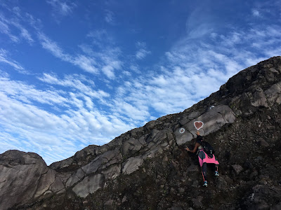
| Climbing Mount Agung from Pura Pasar Agung to Summit |
 |
| Crater Rim of Mount Agung from Kubu |
 |
| Emergency camp on the slope of Mount agung |
 |
| Very steep slope of Mount Agung from Kubu |
2. Mt. Batukaru 2276 m/ 7467 feet
Even though the elevation is not that high, but the start point is not high either, that means it's a long trek. It has 3 different start point as well. Could be slippery and many leeches in rainy season. Takes about 3 hours, if you are fit. There is a temple on the top, enough for 3 tents to camp.
-From Pura Luhur Batukaru. I have tried one time, using a guide that you can hire at the entrance gate of the temple. It's a pretty long and constant steep (slippery in rainy season). There are some confusing junction, lucky that I had a guide. Once you reach the tunnel under the ferns, you are 200 meters away from the top.
-From Pura Pucak Petali, Jatiluwih. This is my favorite path, start on the right side of the temple. You will see a smaller temple and the jungle start on the left side of it. The trek is pretty steep, inside the lush tropical jungle.
-From Pupuan. I haven't tried, the trail starts from Pura Malen.
 |
| View from the top of Mount Batukaru |
 |
| View of tamblingan lake from the top of Mount Batukaru |
 |
| View from the top of Mount Batukaru |
3. Mt. Abang (2151 m/ 7057 feet)
There is only one trail that I know, the other trails sounds pretty risky. the start point is in the end of the road here -8.285799,115.409476. About 2-3 hours hike, pretty steep but fun. Not recommended to do in heavy rain, since the trail will be very slippery and close to the cliff.
 |
| The temple on the top of Mount Abang(but they have change it) |
 |
| The view from Mount Abang |
There is a beautiful on the top, cool view surrounding when the weather is good. The top is flat, enough to built up to 3 tents, and there are 3 gazebo.
There are two routes that I know.
- From Danau Bratan, Bedugul. I haven't tried and I'm still not sure where exactly is the start point.
- From the end of the Pura Pucak Mangu Street. Most part of the trail are really proper, because many Balinese going up for praying. But in 2017, heavy rain have destroyed some part.
 |
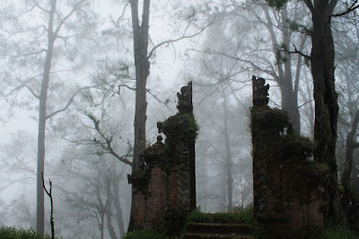
| Pura Pucak Mangu on Mount Catur |
5. Mt. Sangiyang (2087 m/ 6847 feet)
It has two peaks that you can see from Mt. Batukaru, the easy way stated on the side of a temple here -8.295269, 115.100616. The trekking is pretty short, typical forest around Batukaru. Kind of sad that people cut the trees to set tent for praying. And of course they dumb garbage all around, just like Mount Abang.
6. Mt. Pohen (2063 m/ 6768 feet)
I haven't been there, I have read that there is a road to go up, since they built a Geothermal Site.
7. Mt. Tapak (1909 m/ 6263 feet)
Easy trail, pretty steep but fun. Start from Bali Botanical Garden in Bedugul. There is a small temple and cemetery of Muslim Imam. So you might find them staying overnight to pray.
 |
| Lush Jungle of Mount Tapak |
 |
| On the Top of Mount Tapak |
8. Mt. Lesung (1865 m/ 6118 feet)
There are two trail that I know and I have tried both of them. There is a small temple on the top, surrounded by trees. You will need to climb it if you want to see the view. Try to go down to the old crater and find the mysterious Lubang Nagaloka.
-From Pura Dalem Tamblingan. The trail is easy, but you will meet some intersection, i got lost one time.
-From here -8.286191, 115.100523. How do i find it? By google map :) This is easier and pretty short trail, but we need to go around the crater rim to get to the summit.
 |
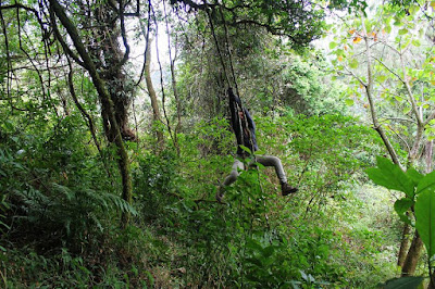
| Swinging in the jungle of Mount Lesung |
9. Mt Adeng (1826 m/ 5990 feet)
I haven't been there.
10. Mt Batur (1717 m/ 5633 feet)
It's the most famous one, very touristy, but very beautiful as well. I have been here many times. There are different ways to go up, whether pay or not.
-From the Association, very expensive and you have to use a local guide, otherwise they will chase you. And you will walk on the same trail with 200-500 tourists.
-From another start point, for free, but it's a secret! It will ended up at the same point, you can go around the crater rim after sunrise.
 |
| Mount Batur Sunrise |
 |
| Walking on mount Batur Crater Rim |
 |
| Mount Batur Crater Rim and View |
11. Mt. Seraya, Pura Lempuyang Luhur.
Start from the right side of beautiful Pura Penataran Agung Lempuyang, you can visit different temples on the way to Pura Lempuyang Luhur. If you visit in the dark, you might have chance to see different kind of moth.
 |
| Atlas Moth |
Need more information? Contact me at winaajah@gmail.com or WhatsApp +6285737159359

No comments:
Post a Comment